


Our Main Office
Construction Equipment Guide
470 Maryland Drive
Fort Washington, PA 19034
800-523-2200
Tue March 21, 2023 - National Edition #18
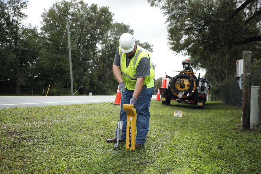
Vermeer continues to support the utility industry with the Vermeer Verifier G3+ utility locator launch.
This new-generation locator delivers high accuracy, optimized connectivity and intuitive controls. The Verifier G3+ utility locator pairs with smartphones using the G3+ Map mobile app (available for IOS and Android) to plot location information, including depth, current index, GPS data, utility type, device name and the operator who performed the work.
The data-capturing ability of the Verifier G3+ locator allows contractors and utility owners to capture and store information about construction projects. That means they also can provide more information to their teams and customers.
"Tracking and storing records about the specific location of underground utilities is vital," explained Aaron James, product specialist II at Vermeer MV Solutions.
"With many lines out-of-sight in the congested areas, identifying and tracking one from another can be challenging. The technology that powers the Vermeer Verifier G3+ utility locator helps operators accurately identify and track individual utilities in crowded rights-of-way. Its water-resistant, rugged design is well suited to the harsh everyday conditions that operators work in."
The GPS-enabled Verifier G3+ utility locator can determine underground current direction against adjacent signals from other utilities. It can detect ambient noise so the operator can switch to a different frequency for a particular jobsite. Also, operators can adjust transmitter frequency and power outputs from up to 500 ft (152.4 m) away using a wireless connection.
Saved data from the locator is transferred using Bluetooth 5.0 to the G3+ Map app. The data also can be uploaded to the Vermeer Projects bore planning tool.
The Vermeer Verifier G3+ offers operators three locating modes: peak, peak/null and null. It has a water-resistant, one-size-fits-all coil clamp that does not need to encircle a utility to induce a signal. They also can add a mini probe to track the location and depth of non-metallic pipe accurately.
This latest generation of Vermeer utility locators replaces the standard Verifier G3 utility locator and comes with three-year coverage.
For more information, visit vermeer.com.
Construction Equipment Guide
470 Maryland Drive
Fort Washington, PA 19034
800-523-2200
Construction Equipment Guide covers the nation with its four regional newspapers, offering construction and industry news and information along with new and used construction equipment for sale from dealers in your area. Now we extend those services and information to the internet. Making it as easy as possible to find the news and equipment that you need and want.
Contents Copyrighted 2024, by Construction Equipment Guide, which is a Registered Trademark, registered in the U.S. Patent Office. Registration number 0957323. All rights reserved, nothing may be reprinted or reproduced (including framing) in whole or part without written permission from the publisher. All editorial material, photographs, drawings, letters, and other material will be treated as unconditionally assigned for publication and copyright purposes and are subject to Construction Equipment Guide’s unrestricted right to edit and comment editorially. Contributor articles do not necessarily reflect the policy or opinions of this publication.
Read our privacy policy here.
Mastodon